Mehrhoog: Difference between revisions
Jump to navigation
Jump to search
Knorrepoes (talk | contribs) m (Text replacement - "/Arms of " to "/Arms (crest) of ") |
Knorrepoes (talk | contribs) m (Text replacement - "{{media}}" to " {{de1}} {{media1}}") |
||
| Line 24: | Line 24: | ||
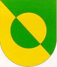
The arms show a circle, based on the arms of Hamminkeln. The arms symbolise the structure of the soil in the municipality, the sandy heathlands and the green fields. The division line also symbolises the railway line that runs through the village from North-West to South-East. | The arms show a circle, based on the arms of Hamminkeln. The arms symbolise the structure of the soil in the municipality, the sandy heathlands and the green fields. The division line also symbolises the railway line that runs through the village from North-West to South-East. | ||
{{ | |||
{{de1}} | |||
{{media1}} | |||
[[Civic Heraldry Literature - Germany|'''Literature''']]: http://www.hamminkeln.de | [[Civic Heraldry Literature - Germany|'''Literature''']]: http://www.hamminkeln.de | ||
Revision as of 11:09, 26 December 2022
This page is part of the  |
 |
|
German heraldry:
|
Selected collector's items from Germany:
|
MEHRHOOG
State : Nordrhein-Westfalen
District (Kreis) : Wesel (until 1969 Rees)
Incorporated into : 1969 Hamminkeln

| German | |
| English | No blazon/translation known. Please click here to send your (heraldic !) blazon or translation |
Origin/meaning
The village never was a separate municipality, but until 1969 belonged to Haffen-Mehr.
The arms show a circle, based on the arms of Hamminkeln. The arms symbolise the structure of the soil in the municipality, the sandy heathlands and the green fields. The division line also symbolises the railway line that runs through the village from North-West to South-East.