Dahlheim (Staufenberg): Difference between revisions
Jump to navigation
Jump to search
Knorrepoes (talk | contribs) No edit summary |
Knorrepoes (talk | contribs) No edit summary |
||
| Line 12: | Line 12: | ||
Incorporated into : 1973 [[Staufenberg (Niedersachsen)|Staufenberg]] | Incorporated into : 1973 [[Staufenberg (Niedersachsen)|Staufenberg]] | ||
[[File:dahlheim2.jpg | [[File:dahlheim2.jpg|center]] | ||
====Origin/meaning==== | ====Origin/meaning==== | ||
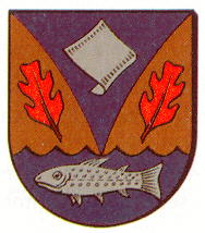
The arms show that the village is situated between two forested hills. The base symbolises the Nieste river, which historically was important for trout fishing, hence the trout in the base. The river also drove for many centuries a papermill, which is symbolised by the sheet of paper in the upper half of the arms. | The arms show that the village is situated between two forested hills. The base symbolises the Nieste river, which historically was important for trout fishing, hence the trout in the base. The river also drove for many centuries a papermill, which is symbolised by the sheet of paper in the upper half of the arms. | ||
Revision as of 09:21, 28 June 2013
 |
Heraldry of the World Civic heraldry of Germany - Deutsche Wappen (Gemeindewappen/Kreiswappen) |
|
DAHLHEIM
State : Niedersachsen
District (Kreis) : Göttingen
Incorporated into : 1973 Staufenberg

Origin/meaning
The arms show that the village is situated between two forested hills. The base symbolises the Nieste river, which historically was important for trout fishing, hence the trout in the base. The river also drove for many centuries a papermill, which is symbolised by the sheet of paper in the upper half of the arms.
Literature : Information provided by the Staufenberg_council.